


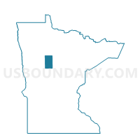
Clay Twp. Voting District, Hubbard County, Minnesota
About
Outline

Summary
| Unique Area Identifier | 602536 |
| Name | Clay Twp. Voting District |
| County | Hubbard County |
| State | Minnesota |
| Area (square miles) | 36.18 |
| Land Area (square miles) | 33.71 |
| Water Area (square miles) | 2.47 |
| % of Land Area | 93.18 |
| % of Water Area | 6.82 |
| Latitude of the Internal Point | 47.11721530 |
| Longtitude of the Internal Point | -94.95072410 |
Maps

Graphs
Select a template below for downloading or customizing gragh for Clay Twp. Voting District, Hubbard County, Minnesota


Neighbors
Neighoring Voting District (by Name) Neighboring Voting District on the Map
- Arago Twp. Voting District, Hubbard County, MN
- Clover Twp. Voting District, Hubbard County, MN
- Hendrickson Twp. Voting District, Hubbard County, MN
- Lake Alice Twp. Voting District, Hubbard County, MN
- Lake Emma Twp. Voting District, Hubbard County, MN
- Lake George Twp. Voting District, Hubbard County, MN
- Mantrap Twp. Voting District, Hubbard County, MN
- Thorpe Twp. Voting District, Hubbard County, MN
Top 10 Neighboring County Subdivision (by Population) Neighboring County Subdivision on the Map
- Lake Emma township, Hubbard County, MN (985)
- Arago township, Hubbard County, MN (607)
- Mantrap township, Hubbard County, MN (519)
- Lake George township, Hubbard County, MN (378)
- Hendrickson township, Hubbard County, MN (314)
- Clover township, Hubbard County, MN (154)
- Lake Alice township, Hubbard County, MN (93)
- Clay township, Hubbard County, MN (69)
- Thorpe township, Hubbard County, MN (49)
Top 10 Neighboring Unified School District (by Population) Neighboring Unified School District on the Map
- Park Rapids Public School District, MN (12,088)
- Nevis Public School District, MN (2,492)
- Laporte Public School District, MN (1,764)